


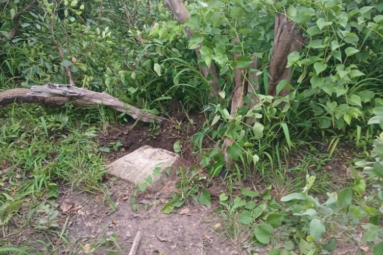
Gambiaj.com – (BANJUL, The Gambia) – For more than a century, some of the most important objects on The Gambia’s international frontier have been sitting quietly in the bush. They are not monuments in the conventional sense. They carry no grand inscriptions and attract few visitors. But the concrete-and-stone pillars erected along the Gambia-Senegal boundary more than 120 years ago perform a task that goes to the heart of statehood: they help show where one country ends and another begins.
Today, some of those pillars are difficult to find.
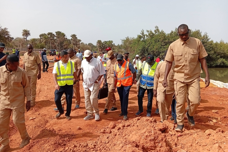
Teams from The Gambia and Senegal have had to cut through thick vegetation, cross creeks and ponds, and search deep inside forests to locate and identify the surviving colonial markers. Surveyors need clear sightlines around the pillars to take accurate Global Navigation Satellite System coordinates.
In some places, chainsaws, cutlasses, and long knives have become as important to the field operation as surveying equipment.
The difficulty is not simply the result of nature reclaiming the landscape.
It is also part of a much longer story about how a small state maintained, and eventually stopped maintaining, the physical infrastructure of its own territorial boundary.
A small budget for a big responsibility
According to Hassoum Ceesay, Director General of the National Centre for Arts and Culture and a historian involved in the current demarcation exercise, the colonial administration understood that putting a pillar on the ground was only the beginning.
The pillars were reportedly fenced off with wire mesh or strong keno logs to protect them from cattle and other animals. After independence, the practice continued through local administration.
Up to the mid-1980s, Ceesay says, the national budget included D100 for the protection of each boundary pillar. The money went to chiefs, and in some cases through Area Councils, to ensure that the markers were fenced and remained visible and protected.
It was a remarkably modest expenditure for something with such strategic significance.
The fencing also had a practical effect. A protected and recognizable pillar was easier for communities to identify and less likely to disappear beneath vegetation or be damaged by animals.
Then, in 1985, the allocation disappeared. An obscure budget cut in the 1980s became part of the story behind The Gambia’s difficult search for its colonial boundary pillars.
Ceesay links that decision to The Gambia’s Economic Recovery Program and the structural adjustment policies introduced as the country faced a severe economic crisis.
The historical record confirms the depth of that crisis.
By 1985-86, The Gambia’s gross official reserves had fallen to less than a week of imports, while external public debt had risen to 113 percent of GDP. The government subsequently introduced a comprehensive adjustment program aimed at restoring financial stability and reducing the size and cost of the public sector.
The adjustment included substantial civil-service retrenchment and reductions in public expenditure. World Bank records, for example, document the removal of thousands of temporary and permanent public-sector workers as part of the restructuring process.
Ceesay’s account goes further, arguing that the same drive to cut expenditure also ended the small budget for boundary-pillar protection.
There is an important distinction here. The IMF and World Bank records document the wider fiscal and structural adjustment program and public-sector retrenchment; they do not, in the material reviewed for this story, specifically identify the D100 boundary-pillar allocation as a Bretton Woods-imposed cut.
It took us Ceesay’s historical explanation of what happened to the pillar-protection budget to make the broader consequence easier to see.
Once routine maintenance disappeared, the boundary markers were increasingly left to the elements, vegetation, animals, and the passage of time.
The cost of forgetting
The irony is that D100 was never really about the value of a concrete pillar.
It was about maintaining a system.
The original boundary itself was the product of a lengthy colonial process. British and French authorities spent 17 years, from 1889 to 1905, working out and defining the frontier. Early markers included natural features such as trees, ponds, bolongs, and footpaths. Those proved unreliable: trees could be uprooted by storms and ponds could dry up.
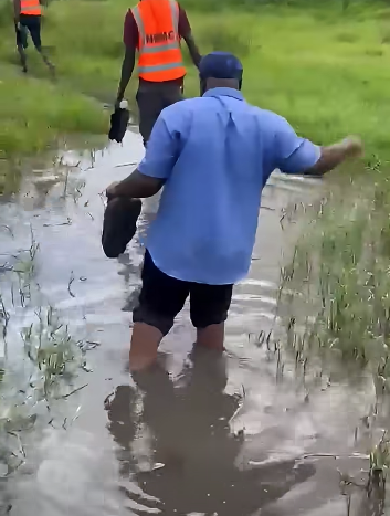
Finding Boundary pillars also involves fording creeks and ponds, as some pillars are found on riverbanks.
The colonial authorities eventually moved towards permanent physical markers.
Archival material held by the British Library records maps from 1904 and 1905 showing the Anglo-French Commission re-cutting sections of the frontier and erecting new pillars.
According to NCAC records, 61 of the original colonial pillars were erected between 1904 and 1905. They were constructed to a common design using cement and stone, without iron reinforcement. An undisturbed original pillar has a distinctive base, middle section, and cap held together by a stone joint.
The colonial administration therefore did not merely draw a line on a map. It created a physical system for translating that line into the landscape.
The problem came later when the institutional machinery for maintaining parts of that system weakened.
Now the search begins again.
The consequences are visible in the current joint demarcation exercise.
The first phase of the latest Gambia-Senegal operation covered nearly 30 kilometers between Dimbaya in Kombo and Kanao in Foni and lasted six weeks.
The joint team reaffirmed existing colonial pillars, recorded their coordinates, and installed new markers where necessary. Nine agreements were signed at the end of the first phase, with documentation intended to accompany the pillars and the technical work.
Earlier in the exercise, teams had already located 20 old colonial-era pillars in areas including Foni Brefet and Dimbaya.
But finding a pillar is not simply a matter of walking along a line shown on an old map.
The landscape has changed.
Trees have grown. Paths have shifted. Settlements have expanded. Watercourses have altered. What may once have been a clearly visible marker can now be buried in vegetation or hidden beneath a canopy.
And even when a pillar is found, surveyors must determine exactly what it is.
NCAC has warned that not every pillar encountered along the border is necessarily one of the original colonial markers. Some may be later geodetic or district boundary pillars. Historical records therefore have to be compared with what exists physically on the ground.
This is why the current exercise is as much archival as it is technical.
The price of maintaining sovereignty
There is a broader lesson in the story of the D100.
States tend to notice sovereignty when it becomes politically visible, when a fence is built, when soldiers appear, when a border crossing becomes controversial, or when neighboring countries disagree over territory.
But sovereignty also depends on quieter things: surveys, archives, maps, coordinates, records, maintenance, and people who know where the markers are.
The recent experience at the Gambia-Senegal border demonstrates how quickly the absence of such routine investment can become a much larger problem.
A small annual allocation to fence a pillar may have seemed insignificant during an economic crisis in which the government was struggling to pay for much more basic needs. The Economic Recovery Program was designed to address serious macroeconomic imbalances, and official records show that the adjustment produced important improvements in fiscal and external stability.
But austerity has consequences beyond the figures recorded in budgets.
In the case of the boundary pillars, one of those consequences appears decades later in the form of survey teams hacking their way through forests to rediscover pieces of the country’s territorial history.
The lesson is not necessarily that every historical budget line should survive every economic crisis.
It is that some seemingly minor public expenditures carry responsibilities that are difficult to replace once they disappear.
The D100 was not merely money for fencing.
It was money for keeping the boundary visible.
Four decades after that allocation disappeared, The Gambia and Senegal are now spending considerably more time, expertise, and technical resources trying to make that same boundary visible again.





Leave a Reply